| Table | Rows | Purpose |
|---|---|---|
cell |
661,372 | Grid cells of the study area, with environmental covariates and membership flags. |
taxon |
17,561 | One row per taxon: identity, category, extinction risk and validity flags. |
model |
30,430 | Registry of every distribution model, keyed by the stable model identifier. |
metric |
35 | Metric registry: key and description for each scored quantity. |
cell_metric |
21,990,083 | Per-cell score for each metric — the surface the maps draw. |
zone |
76 | Zone registry keyed by source table, field and value, so every spatial unit shares one schema. |
zone_cell |
4,626,531 | Zone membership: which cells belong to which zone. |
zone_metric |
774 | Pre-aggregated per-zone score for each metric — what drives the choropleth. |
zone_taxon |
61,219 | Per-zone species list with each species’ contribution to the zone score. |
dataset |
8 | Source datasets, with citations, vintages and whether each fed the scores. |
taxon_model |
29,805 | Which models fed which taxon — the taxon to model relation. |
listing |
718 | US federal listing lookup (ESA status, MMPA and MBTA protection). |
15 Database
The source of truth for the Marine Sensitivity Toolkit is DuckDB — a columnar, embedded analytic database. It is fast enough to answer live per-cell queries while remaining a single-file artifact that can be copied, versioned and served read-only to many processes at once.
The pipeline writes a working database (sdm.duckdb) on the machine that runs it; a release is the published, immutable form of that database’s tables. Since the marine-atlas release format, each version is published as partitioned Parquet on S3 under marine-atlas/{ver}/tables/, and serving reads it through a tiny view-only DuckDB (serve.duckdb, kilobytes) whose tables are views over those files — never a multi-gigabyte copy.
Everything below is read from the release this build documents (v3), so the tables, columns and row counts are those of that version rather than of whichever version happened to be current when the page was written.
Note
Why DuckDB and not PostgreSQL? Earlier versions of the stack used PostgreSQL + PostGIS as the primary store. As the analysis stabilized around a fixed 0.05° cell grid and a small set of zone layers, live geometry operations and concurrent writes stopped being needed — only fast analytic reads. DuckDB scans tens of millions of rows in well under a second with no separate server process. PostGIS is no longer part of the serving path (see Chapter 14).
15.1 Table and column naming conventions
- Table names are singular and lower case.
- Unique identifier columns are suffixed with:
*_idfor unique integer keys (stable across rebuilds);*_keyfor unique string keys (human-readable and stable across releases);*_seqfor auto-incrementing sequence integer keys (internal join keys, not stable across rebuilds).
- Column names are singular and use
snake_case. - Foreign keys use the singular form of the referenced table, followed by the primary-key suffix (
_id,_key, or_seq).
Important
value is a reserved word in DuckDB
Cell values are stored in a column named val, not value. The serving views expose val AS value for backward compatibility with callers written against the older schema.
NoteNot published by v3
model_asset, native_asset. Sections that depend on these are omitted from this build rather than described from another release.
15.2 Schema
The columns of each published table, read from the release:
15.2.1 cell
| Column | Type |
|---|---|
| cell_id | INTEGER |
| depth_mean | DOUBLE |
| depth_min | DOUBLE |
| depth_max | DOUBLE |
| oxy_b_mean | DOUBLE |
| oxy_mean | DOUBLE |
| prim_prod_mean | DOUBLE |
| ice_con_ann | DOUBLE |
| salinity_b_mean | DOUBLE |
| salinity_mean | DOUBLE |
| sbt_an_mean | DOUBLE |
| sst_an_mean | DOUBLE |
| fao_area_m | DOUBLE |
| area_km2 | DOUBLE |
| width_km2 | DOUBLE |
15.2.2 taxon
| Column | Type |
|---|---|
| taxon_id | DOUBLE |
| taxon_authority | VARCHAR |
| n_ds | INTEGER |
| ms_merge | INTEGER |
| sp_cat | VARCHAR |
| mdl_seq | INTEGER |
| scientific_name | VARCHAR |
| common_name | VARCHAR |
| worms_id | INTEGER |
| redlist_code | VARCHAR |
| extrisk_code | VARCHAR |
| er_score | INTEGER |
| is_mmpa | BOOLEAN |
| is_mbta | BOOLEAN |
| is_bcc | BOOLEAN |
| worms_is_marine | BOOLEAN |
| worms_is_extinct | BOOLEAN |
| esa_code | VARCHAR |
| esa_source | VARCHAR |
| is_ok | BOOLEAN |
| worms_taxonomic_status | VARCHAR |
15.2.3 model
| Column | Type |
|---|---|
| mdl_seq | INTEGER |
| ds_key | VARCHAR |
| taxa | VARCHAR |
| time_period | VARCHAR |
| region | VARCHAR |
| mdl_type | VARCHAR |
| description | VARCHAR |
| date_created | DATE |
15.2.4 metric
| Column | Type |
|---|---|
| metric_seq | INTEGER |
| metric_key | VARCHAR |
| description | VARCHAR |
| date_created | DATE |
| metric_title | VARCHAR |
| metric_abbrev | VARCHAR |
15.2.5 cell_metric
| Column | Type |
|---|---|
| cell_id | INTEGER |
| metric_seq | INTEGER |
| value | DOUBLE |
15.2.6 zone
| Column | Type |
|---|---|
| zone_seq | INTEGER |
| tbl | VARCHAR |
| fld | VARCHAR |
| value | VARCHAR |
| date_created | DATE |
15.2.7 zone_cell
| Column | Type |
|---|---|
| zone_seq | INTEGER |
| cell_id | INTEGER |
| pct_covered | INTEGER |
15.2.8 zone_metric
| Column | Type |
|---|---|
| zone_seq | INTEGER |
| metric_seq | INTEGER |
| value | DOUBLE |
15.2.9 zone_taxon
| Column | Type |
|---|---|
| zone_tbl | VARCHAR |
| zone_fld | VARCHAR |
| zone_value | VARCHAR |
| mdl_seq | INTEGER |
| sp_cat | VARCHAR |
| sp_common | VARCHAR |
| sp_scientific | VARCHAR |
| taxon_id | DOUBLE |
| taxon_authority | VARCHAR |
| rl_code | VARCHAR |
| er_score | INTEGER |
| is_mmpa | BOOLEAN |
| is_mbta | BOOLEAN |
| is_bcc | BOOLEAN |
| esa_code | VARCHAR |
| esa_source | VARCHAR |
| area_km2 | DOUBLE |
| avg_suit | DOUBLE |
| suit_rl | DOUBLE |
| suit_rl_area | DOUBLE |
| cat_suit_rl_area | DOUBLE |
| pct_cat | DOUBLE |
15.2.10 dataset
| Column | Type |
|---|---|
| ds_key | VARCHAR |
| name_short | VARCHAR |
| name_original | VARCHAR |
| description | VARCHAR |
| citation | VARCHAR |
| source_broad | VARCHAR |
| source_detail | VARCHAR |
| regions | VARCHAR |
| response_type | VARCHAR |
| taxa_groups | VARCHAR |
| year_pub | INTEGER |
| date_obs_beg | DATE |
| date_obs_end | DATE |
| date_env_beg | DATE |
| date_env_end | DATE |
| link_info | VARCHAR |
| link_download | VARCHAR |
| link_metadata | VARCHAR |
| links_other | VARCHAR |
| spatial_res_deg | DOUBLE |
| temporal_res | VARCHAR |
| date_created | DATE |
| name_display | VARCHAR |
| value_info | VARCHAR |
| is_mask | BOOLEAN |
| sort_order | INTEGER |
15.2.11 taxon_model
| Column | Type |
|---|---|
| taxon_id | DOUBLE |
| ds_key | VARCHAR |
| mdl_seq | INTEGER |
15.2.12 listing
| Column | Type |
|---|---|
| spp_id | DOUBLE |
| worms_id | DOUBLE |
| botw_id | DOUBLE |
| extrisk_code | VARCHAR |
| er_score | INTEGER |
| is_mmpa | BOOLEAN |
| is_mbta | BOOLEAN |
| is_bcc | BOOLEAN |
| common_name | VARCHAR |
15.3 Asset store
NoteOld copies remain until the prune
Every published release (v7, v7b, v8, v9) has pointed only into the store since the asset-store migration of 2026-10-02. The copies the v8 and v9 releases carried before it still exist under their release prefixes (v8/native/, v9/native/) and on the file host, unreferenced, until a prune that follows a soak period. The migration’s listing on 2026-10-01 found 145,452 objects (33.08 GB) under those two prefixes, which collapse to 86,421 distinct keys (19.63 GB) in the store, because the two releases carry the same files for most datasets.
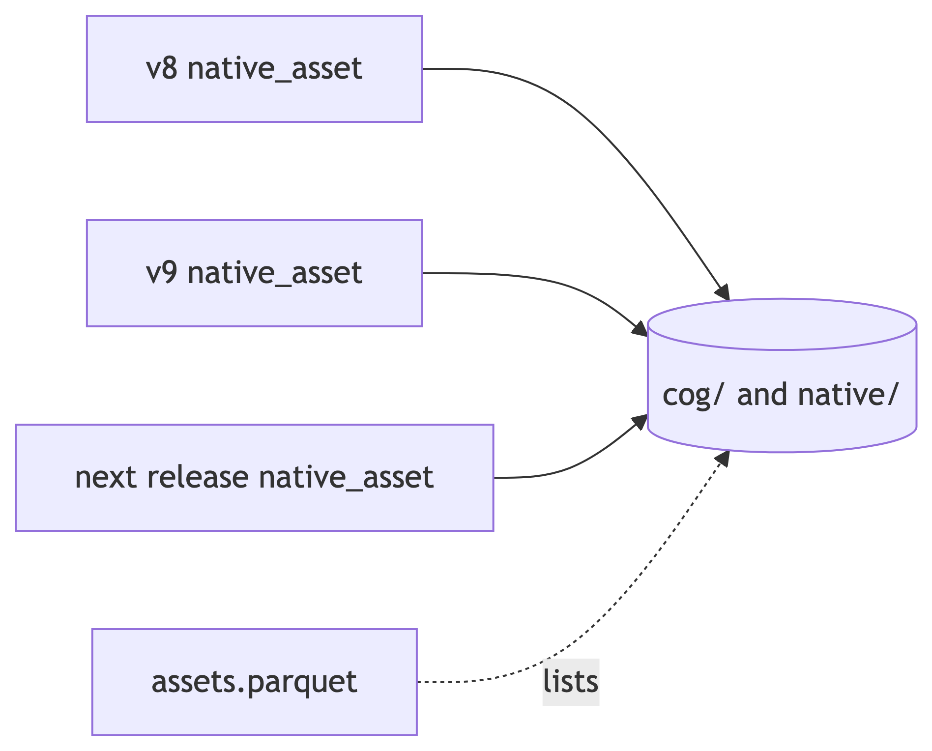
A release owns pointers, never distribution files. Every cloud-optimized distribution file lives exactly once in an unversioned, content-addressed store, and each release publishes tables whose rows point into it. Nothing ending in .tif or .pmtiles is written under a release’s {ver}/ prefix. A release prefix holds only its manifest, its tables, its app bundle and its serving files.
There are two stores, both in the project’s public S3 bucket:
| Store | Key | Holds |
|---|---|---|
cog/ |
cog/{grid_id}/{hash}.tif |
rasters on an analysis grid: each input’s gridded surface, merged models and score surfaces |
native/ |
native/{ds_key}/{hash}.{tif\|pmtiles} |
each source dataset’s own resolution original: a raster (.tif) or a vector range (.pmtiles) |
15.3.1 The key comes from the content
The hash in a key is computed before any file is built, from the source content of the model plus an encoding tag, and never from the bytes of the file or from the release:
- for a gridded surface, the model’s
(cell_id, val)rows; - for a native raster, the source grid’s
(cell_id, val)rows; - for a native vector range, the normalized geometry and the attributes that reach the tile;
- the encoding tag names how the file is written (data type, nodata, overviews, tile scheme), so a different encoding of the same content is deliberately a different object.
Two consequences follow. A surface that did not change between releases is found in the store by its key, so it costs neither a build nor an upload; a source dataset such as AquaMaps that is unchanged between releases is registered by a new pointer row and nothing else. And a merged model that equals its only input has the same rows, hence the same key, hence is the same object as that input, with no special case. A re-ingested dataset adds objects only for the models whose content changed; the old objects stay for the releases that still point at them. Scores are always new, because they are per-release tables.
15.3.2 The catalog and the pointer table
assets.parquetat the atlas root (beside thecog/andnative/stores, under the samemarine-atlas/prefix as the releases) is the catalog, with one row per stored object (store, key, content hash, encoding tag, asset type, grid or dataset key, size, MD5, creation time and the first release that used it). “Is it already stored?” is an anti-join against this file, not a bucket listing.native_assetis the per-release pointer table (Table 15.1). Itsrepresentation = modelrows point intocog/, itsnativerows point intonative/, and a merged model is a row withds_key = ms_merge. Each row carries the content hash and the asset URL; a PMTiles row also carriessource_key, the model key the tile’s features are tagged with, which is how a viewer filters one range out of the archive. Every published release has one in this shape; the earlier releases keepmodel_assetbeside it so that old links still resolve.- An object no release points at is garbage. Nothing is deleted except through a check that joins the catalog against every release’s pointer tables.
15.3.3 Finding a file
The bucket denies anonymous listing, so a file is found through a pointer, not by browsing:
- read the catalog
assets.parquetto see what exists and where; - read a release’s
native_assettable ({ver}/tables/native_asset.parquet) to see which objects that release uses for each model; - or ask STAC: the searchable STAC API is built from the pointer table, so each Item’s
modelandnativeassets carry the same store URLs, and the static STAC catalog of a release links them once its tree is rebuilt from the pointer table (every published release today).
15.3.4 Verify before store
An object is admitted to the store under key K only if its decoded pixels equal the rows K was computed from. In the migration, a file that failed the check was repainted from the model’s current rows and uploaded under its key (2,934 of the raster objects; the rest were copied once their pixels had been verified). A publish applies the same check to every new file before it is uploaded. This keeps what a map draws identical to what the scores used.
See Section 16.3 for how a publish writes to the store and what the publish gate checks.
15.4 How the tables feed the serving tier
- Score rasters — per-cell scores are published as Cloud-Optimized GeoTIFFs, one per metric × subregion, and the app reads the href and rescale range straight from the release manifest. Earlier releases rendered them by sending SQL to a tile factory per request; that path is retired (see Chapter 14).
- Per-model distributions —
model_cellis published partitioned by a dense integer model id, so a tile request reads exactly one partition as a point read rather than scanning the surface. - Zone choropleths —
zone_metricjoined tozonegives the per-zone score; the geometry comes from PMTiles published per zone-set vintage, and the manifest names the vintage each release used. Only the paint specification changes when the reader switches metric. - Per-cell and per-area species lists — the same rows partitioned by a spatial tile instead (
cell_model), because a per-cell question against a model-partitioned surface would scan everything.
See Chapter 16 for the notebooks that build each of these tables.