Marine Sensitivity
Project Documentation

Preface
The Marine Sensitivity Toolkit (MST) is a cloud-native system developed for the Bureau of Ocean Energy Management (BOEM) to assess the sensitivity of marine ecosystems to offshore energy development.
It integrates 9,795 species distribution models with extinction risk assessments across US waters (9,621 of which fall within the 20 BOEM Program Areas of the current program cycle).
Merged models + extinction risk
Datasets — NMFS core areas added — designated regions of concentrated use, a targeted high-confidence habitat indicator rather than a broad-coverage model.
Methods — Extinction risk is reworked into a single governing er_score per taxon, taken as the most protective across its datasets with a US national listing overriding the international IUCN category, plus statutory floors for the MMPA (marine mammals) and MBTA (migratory birds). Merging now runs for every taxon, masked to the IUCN range where one exists.
Reported units — Scores are reported on the 20 Program Areas only. The Planning Area geometry is still carried in the database, and a couple of non-composite metrics with it, but no composite score is computed for it — from here on, Planning Areas are history rather than a reporting unit. (measured: 20 programarea scored on the composite metric.)
Scope — Taxonomy is tightened: every source name resolves to a canonical WoRMS or BirdLife identity, and non-marine and extinct taxa are dropped. Sea turtles become their own category, and non-turtle reptiles stop being scored. This roughly halves the valid-species count — a change in definition, not a loss of data.
Measured against v2: datasets added: ca_nmfs; valid species 17,353 → 9,795.
Interactive Apps
- Composite scores — sensitivity scores by zone, with flower-plot summaries
- Individual species — individual species distribution models and habitat suitability
Both render any published release: substitute the version in the URL path (e.g. /v3/scores/) to view that one; an older ?ver=v3 link still resolves, 301’d to the equivalent path.
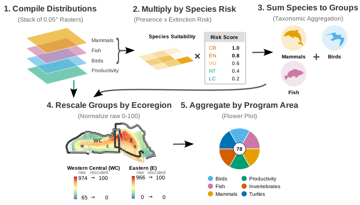
- Scoring walkthrough — step through the scoring pipeline interactively, from input rasters to final scores
Documentation
This book documents the scientific methodology, software infrastructure, and interactive applications that comprise the MST. It is organized in two parts:
- 5 Science — data sources, taxonomic integration, extinction risk scoring, model merging, and sensitivity scoring methodology
- 13 Software — server architecture, databases, workflows, APIs, R libraries, and interactive applications
How to Cite
Best, B.D., T.P. White (2026). Marine Sensitivity Toolkit: Project Documentation. Bureau of Ocean Energy Management, Environmental Studies Program. https://marinesensitivity.org/docs/
Acknowledgments
This work is funded by the BOEM Environmental Studies Program (BOEM-ESP). We thank the data providers whose open datasets make this work possible: AquaMaps, BirdLife International, IUCN Red List, NOAA Fisheries, and U.S. Fish & Wildlife Service.